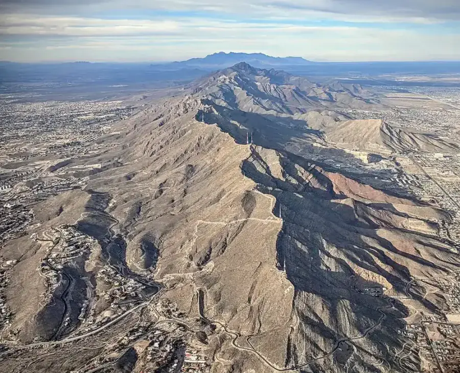
Which side of the Franklin Mountains your property sits on decides almost everything about your well. East of the range is the Hueco Bolson, west is the Mesilla Bolson, and together they form the Hueco-Mesilla Bolsons aquifer, which the Texas Water Development Board records as covering 1,370 square miles across two Texas counties, with availability of 183,000 acre-feet per year for the 2010 to 2060 planning period.
El Paso Water describes roughly 9,000 feet of basin fill in the Hueco against about 2,000 feet in the Mesilla, both extending into New Mexico and Mexico. In a normal year the aquifer supplies about half of El Paso's municipal water, and the Texas Water Development Board records that nearly 90 percent of the water pumped from the two bolsons in Texas goes to public supply. Private wells are drawing from the same resource that the city and Ciudad Juarez depend on.
What 517 filed well reports say about depth
The median completed depth in El Paso County is 160 feet, and 180 feet for wells drilled since 2016. Those figures come from State of Texas Well Reports filed with the Texas Department of Licensing and Regulation, which is the only complete record of legally drilled wells in the county. What matters more than the median is the shape of the distribution.
| Depth band | Wells | Share |
|---|---|---|
| 0 to 50 ft | 18 | 3 percent |
| 50 to 100 ft | 134 | 26 percent |
| 100 to 150 ft | 88 | 17 percent |
| 150 to 200 ft | 32 | 6 percent |
| 200 to 300 ft | 47 | 9 percent |
| 300 to 400 ft | 18 | 3 percent |
| 400 to 600 ft | 55 | 11 percent |
| 600 ft and deeper | 124 | 24 percent |
Compiled from State of Texas Well Reports for El Paso County. Note the two peaks: 46 percent of wells finish shallower than 150 feet, and 24 percent go past 600.
Two peaks, not one. Nearly half of all filed wells finish shallower than 150 feet, then the count thins out through the middle depths and rises sharply again past 600 feet. A single average sitting between those peaks describes almost no real well in the county.
Depth to water, and why the range is so wide
The median static water level across the same records is 15 feet below the land surface, with the middle half of records spanning 9 feet to 175 feet. That is a spread of more than a hundred and fifty feet inside the ordinary middle of the data, and it is the clearest single sign that El Paso County is not one groundwater environment.
It also has practical consequences that show up in repair bills. A pump on a valley well sits a short distance down and costs little to pull. A pump several hundred feet down on a mesa well costs multiples of the same job to service, and it can be stranded above the water entirely if the level falls, which is a problem no new hardware fixes. The Texas Water Development Board records several hundred feet of water level decline in the Hueco Bolson, primarily from municipal pumping.
Water quality: fresher at the top, saltier going down
Salinity is the defining water quality issue in El Paso County, and it varies with depth, with position in the basin and over time. El Paso Water describes the upper Hueco Bolson as containing fresh to slightly saline water at under 1,000 to 3,000 mg per liter of total dissolved solids. The Texas Water Development Board puts the fresher upper part at under 500 to over 1,500 mg per liter, and records that water in the Mesilla Bolson also ranges from fresh to saline with salinity typically increasing to the south and in shallower parts of the aquifer. It adds that water level declines have contributed to higher salinity in both.
What that means when the well is designed
On a deep mesa well, where you set the screen relative to the fresh interval, and which intervals you seal off above and below it, decides the water quality for the life of the well. That decision cannot be undone later with equipment at the house. It is the strongest argument there is for insisting that a quote states the completion method, not just a total.
What it means for an existing well
If an older well has turned salty, the original filed report is the first thing to read. A well screened across both a fresh interval and a deeper saline one can sometimes be reworked to seal off the deeper section, which is a far smaller job than drilling again. Start with a total dissolved solids test and the report, in that order. Well water testing and treatment covers what to test for and what each result actually points to.
Yield is almost never the constraint here
The Texas Water Development Board reports well yields of 150 to 2,000 gallons per minute for the Hueco-Mesilla Bolsons with a mean near 900, and the median tested yield on filed county reports is 700 gallons per minute. Both are dominated by municipal and irrigation wells, which is exactly why they are a poor guide to what your house needs.
A household draws 5 to 10 gallons per minute at peak. A domestic well completed across a thin producing interval may deliver a small fraction of the aquifer-wide figures and still be comfortably adequate. The number that sizes your pump is your own well's tested yield and drawdown, measured during development, not the aquifer's reputation.
How to read a filed State of Texas Well Report
Filed reports are public, free, and the single most useful hour you can spend before requesting quotes. The Texas Water Development Board publishes its Groundwater Database, the Water Data Interactive map and the Submitted Drillers Report Database. Search Water Data for Texas groundwater records →
Four fields carry most of the value. Total depth tells you what the driller had to get through. Static water level tells you how far down the water stood when the well was finished, and comparing an old report with a recent one nearby shows whether the level has moved. The formation log tells you what the ground is made of at your depth. Tested yield tells you what it gave up. Read three or four reports around a property and you have a far better basis for a depth target than any county average provides.
One caveat: a well owner can have report information made confidential under Texas Occupations Code Section 1901.251, so some wells are simply not visible, and wells drilled before the reporting system existed were never filed at all. TWDB groundwater management FAQ → and the TWDB Hueco-Mesilla Bolsons aquifer summary → are the two documents worth keeping open while you read.
With a depth in mind, the cost guide converts it into a budget, and the permit guide covers what Texas requires. For a quote built on the reports near your parcel, send the address through the contact form or check coverage on the service area page.